Remote Sensing
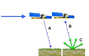
Remote sensing is merely the science of acquiring information about a surface without physically being in contact with it. It involves the use of technical instruments or sensors to record reflected or emitted energy and then processing, analyzing, and applying that information to determine the spectral and spatial relations of distance objects and materials.
 This is possible due to the fact that the examined objects (such as vegetation, buildings, water, air masses etc.) reflect or emit radiation in different wavelengths and intensities according to their current condition. Modern remote sensing typically involves digital processes but can also be done with non-digital methods.
Probably the most common example of remote sensing is an aerial photograph but there are probably hundreds of applications related to remote sensing ranging from space-borne satellites to under-ground geophysical systems. It has become a major component in the evolving Geomatics industry. In order to generate maps for GIS, most remote sensing systems expect to convert a photograph or other data item to actual measurable distance on the surface. However, this almost always depends on the precision of the instrument that is being used to capture the data. For example, distortion in an aerial photographic lens can cause severe distortions when photographs are used to measure ground distances. Using sophisticated software like PCI OrthoEngine can convert the photograph into an ortho photo which can be used to measure ground distances.
In order to coordinate a series of observations, most sensing systems need to know where they are, what time it is, and the rotation and orientation of the instrument. High-end instruments now often use positional information from satellite navigation systems. The rotation and orientation is often provided within a degree or two with electronic compasses.
The resolution determines how many pixels are available in measurement, but more importantly, higher resolutions are more informative, giving more data about more points. However, large amounts of high resolution data can clog a storage or transmission system with useless data, when a few low resolution images might be a better use of the system.
Like I mentioned earlier examples of remote sensing are very numerous. I have over the past decade and have used the many projects that I have been involved with along with actual examples of my work to help illustrate the principals of the various topics covered on the web site. I have included basic overviews for each along with images, presentations, papers and links to other related resources.
